Catanduanes
| Catanduanes | |||
|---|---|---|---|
| — Province — | |||
|
|||
 |
|||
| Coordinates: | |||
| Country | |||
| Region | Bicol Region (Region V) | ||
| Founded | September 26, 1945 | ||
| Capital | Virac | ||
| Government | |||
| - Governor | Joseph Cua (Nacionalista) | ||
| Area | |||
| - Total | 1,492.16 km2 (576.1 sq mi) | ||
| Area rank | 71st out of 80 | ||
| Population (2007) | |||
| - Total | 232,757 | ||
| - Rank | 66th out of 80 | ||
| - Density | 156/km2 (404/sq mi) | ||
| - Density rank | 48th out of 80 | ||
| Divisions | |||
| - Independent cities | 0 | ||
| - Component cities | 0 | ||
| - Municipalities | 11 | ||
| - Barangays | 315 | ||
| - Districts | Lone district of Camarines Norte | ||
| Time zone | PHT (UTC+8) | ||
| ZIP Code | |||
| Spoken languages | Northern Catanduanes Bicolano, Southern Catanduanes Bicolano, Central Bicolano, Tagalog, English | ||
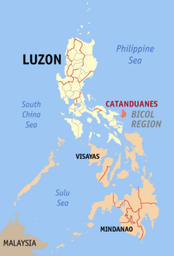
Catanduanes (Filipino:Katandwanes) is an island province of the Philippines located in the Bicol Region in Luzon. Its capital is Virac and the province lies to the east of Camarines Sur across Maqueda Channel. As of 2007, the population of the province is 232,757.
Contents |
Etymology
"Isla de Cobos" was Catanduanes' first adopted name. It was earned as such during the early part of 1573 when Spanish conquistadores came upon several tribes living in the thatched huts called cobos.
Catanduanes, is a hispanized term derived from the word tandu, a native beetle and the samdong tree, which were both found in abundance throughout the island. Common reference to "katanduan" or "kasamdongan", meaning a place where the tandu or the samdong tree thrives in abundance, led to the coining of the word Catanduanes.
History
Pre-Spanish Period
The scions of the then Bornean Datus who had moved on the island of Panay and then, spread out throughout the archipelago were the first settlers to have set foot in Catanduanes. The island was not spared from the adventurous raids of the Moros who came from the island of Mindanao. Because of these destructive raids, many records of the past were destroyed and lost.
Spanish Period
Juan de Salcedo arrived in this island in 1573, hunting for pirates, and conquered the natives. Three years later, a galleon expedition from Acapulco was shipwrecked near the island and the survivors were either killed or made servants. The Batalay Church in Bato, just several kilometers from the capital town of Virac, marks that historical event.
The Christianization of the island started some twenty years later. The conquistadores, after subjugating the Bicol mainland, came back to the island with Franciscan missionaries. From 1600 to 1857, the colonizers were able to put up nine centers of local governments through the establishment of parishes.
American Period
During the American Regime, the local insurgents refused to recognize the sovereignty of the United States. Most of them fled to the mountains. The American occupation did not last long. In 1934, the Americans had ceased control of the island.
World War II
During World War II, Catanduanes was not spared from Japanese invasion. The Japanese erected garrisons in different parts of the island. The Japanese committed so many atrocities in the island province.
Major Salvador Rodolfo (a.k.a. Phantom) organized the Catanduanes Liberation Forces.It was the back bone of the resistance movement in Catanduanes. It performed numerous ambuscades against the Japanese Imperial Army and conducted intelligence gathering, which was necessary in paving the way for the eventual liberation of the province by the Americans. During his exploits as a guerilla leader, Rodolfo was rumored several times to have been killed in battle but time and again he keeps on coming back to destroy every vestige of enemy control in the province of Catanduanes, hence he was called "Phantom" or the Man who never dies.
On February 8, 1945, when Rodolfo was about to declare the independence of the province after he and his men killed every Japanese Imperial Army and burned every Japanese garrison in Catanduanes, one of his men approached him and said that there were Japanese reinforcements on board 2 vessels approaching the island. He then talked to his men, most of whom were wounded and exhausted, he said:
Japanese reinforcements are coming. I have two options for you, we can go to the hills and save ourselves and wait there until the Americans arrive, but I assure you that all civilians left behind will be massacred by the incoming Japanese, or we can repeat what happened in the Battle of Thermopylae and stand our ground. Most of us will die, but we will live forever in the pages of history as the men who fought for the liberation of Catanduanes"
With that, everybody decided to stand their ground and fight the incoming Japanese. They went to their posts to wait for the enemy’s arrival but then, as if by providence, American planes arrived and bombed the Japanese vessels. Rodolfo declared independence of the entire province on February 8, 1945[3].
Independence Day
On October 26, 1946, three months after the Philippine independence from the Americans, the island was finally recognized as a separate and independent province. Commonwealth Act No. 687 was enacted to create the island of Catanduanes as one of the six provinces of the Bicol Region.
Commonwealth Act No. 687 established Catanduanes as a province independent from Albay. It was approved by Congress on September 26, 1945, signed into law by President Sergio Osmena, Sr. on October 24, 1945, and took effect on October 16, 1945.[1]
Geography
Catanduanes is situated in the easternmost fringe of Luzon: 13.3 to 14.1 degrees north latitudes and between 124.1 to 124.3 degrees east longitudes. The island bounded on the West by the Maqueda Channel, on the South by Lagonoy Gulf, and on the North and East by the Philippine Sea (Map 1). Several islands compose the province, but majority of these are physically small to be of relative significance. Its aggregate land area totals approximately 1,511.5 square kilometers or 151,150 hectares. The coastlines, that stretch to almost (248.5 mi) are mostly embayed and coiffed.[2]
The topography is rugged and mountainous, becoming more pronounced towards the central portion of the island. The highest mountain peak is in Boctot, located between the municipalities of Virac and San Miguel, Catanduanes with an elevation of 803 meters (2,600 ft) above sea level. It is the premier mountain range with broadly spread old growth forests and watershed which exerts widespread influence over its immediate environs that include the municipalities of Virac, Bato, and San Miguel. Other prominent mountain forms with important significance include the ranges: Obi in Caramoran, Cagmasoso in San Andres, and the Summit and Magsumoso ranges within the Viga and Gigmoto areas.
The lowlands include the Virac Plain, Viga Plain, San Andres Plain and the Bato River Flood Plain. The coastal municipalities with limited lowland agricultural areas are Pandan and Caramoran. The more extensive lowlands are found in the southern parts of the province. The largest coastal plain is the contiguous wetlands of Viga, Panganiban and Bagamanoc over which lays the widest area of rice paddies and nipa mangroves.
The province is mostly rugged and mountainous terrain. Its slope characteristics are 13% gently sloping to undulating, 1% classified rolling to hilly, 2% very hills and mountains, 47% level to very gently sloping, 32% steep hills and mountainous, and 5% undulating to rolling. Ten of the eleven municipalities of the province are situated along the coastal fringes, over which locate its mostly fractured plains. The only landlocked municipality is San Miguel with its poblacion [town center] sitting in a location entirely devoid of flat lands. The majority of the built-up areas occupy zones that are classified as flat to rolling.
Weather and Climate
Without a pronounced dry season, precipitation is distributed fairly well throughout the year becoming wetter in the last quarter into the early months of the first quarter, when tropical disturbances and monsoon wind bring in heavy rains. Other months are characterized by short periods of dryer days and fine weather except in July and August, when the dry and gusty northwest monsoon winds intensify.
People and Culture
As of May 2000, its total population is 215,356 with an annual growth rate of 1.3% from 1995–2000 and a population density of 142 per sq. kilometer. Almost all of the people of the province are natural born citizens. Naturalized citizens mostly Chinese and some other nationalities is only about one per cent of the population.
The number of households totaled 41,019 with an average household size of 5.25.[3]
Language
Two tongues are being spoken locally. The northern accent has a very pronounced letter R that becomes a diphthong of non-vowel letters L and R in the southern towns. In written form, the conventional mainland Bicol dialect is used. Tagalog, by virtue of being officially taught in schools and the affinity of most Bicolanos to it, is the second most common dialect and easily the most understood by people of all walks of life. English is the normal medium used in primary communications.
Ethnic Groups
More and more people from the neighboring regions are finding peace and security in Catanduanes. Migrants from Visayas and Mindanao regions far outnumber other ethnic groups. A good number of people of Chinese descent are also living in the province.
Traditions
Traditions and inherited lifestyles are being slowly supplanted brought about by a high degree of exposure to the western culture. Significant shift in values, beliefs, morals and customs and outlook in life of younger and future generation will likely take place with the advent of digital information age. State-of-the-art technologies in Communication and Information unheard of in the last decade bring a wide range of information to an increasing number of island residents. Television sets link to satellite cable television system are now common in households notably in areas where local television broadcasts are not accessible, computers linked to the internet, satellite phone and cellular phone services are some of these technologies.
Folk Festivals
The folk festivals celebrated as part of the local religious rituals are with unique traces of the Spanish colonization. Among these festivals are:
- Kalbaryo or Calvary which is commonly staged during the Holy Week is a reenactment of the passion of Christ’s way of the cross.
- Kagharong is a native depiction of the nativity scene is held every year during the yuletide season.
- Pantomina is purely a native dance, popular on occasions of importance. It is a dance interpretation (pantomime) of a rooster courting a hen. Pantomina dance is mostly practice in rural areas.
- Padadyao sa Tinampo is purely native cultural presentation of street dancing held every 24 October to commemorate the province‘s founding anniversary.
- Sugbo Festival is a very recent addition to these traditional festivals. The notable contemporary event is celebrated by the seven barangays of Hitoma in Caramoran that produces sugbo or tiger grass - a bamboo like perennial grass used to make brooms.[4] Celebrated every month of May coinciding with the Hitoma barangay fiesta, it is being institutionalized with the support of the provincial government, LGU of Caramoran and national line agencies to promote the commercial development of the local lasa or tiger grass industry and to create signature products from tiger grass.
Political
Political Divisions
Catanduanes is subdivided into 11 municipalities.
| Municipality | No. of Barangays |
Area (ha.) |
Population (2007) |
Pop. density (per km²) |
|---|---|---|---|---|
| Bagamanoc |
|
|
|
|
| Baras |
|
|
|
|
| Bato |
|
|
|
|
| Caramoran |
|
|
|
|
| Gigmoto |
|
|
|
|
| Pandan |
|
|
|
|
| Panganiban (Payo) |
|
|
|
|
| San Andres (Calolbon) |
|
|
|
|
| San Miguel |
|
|
|
|
| Viga |
|
|
|
|
| Virac |
|
|
|
|
Peace and Order
By comparison, the prevailing peace and order situation in the province is much better than that of the other provinces in the region. This is attributed to the inherent affable character of the Catandunganons, the all-out government support and a vigilant religious hierarchy. To arrest attempts of criminal elements to make the province a market for illegal drugs, the police force with the support of LGUs launched a massive information campaign for a better-informed citizenry.
Police Services - The Philippine National Police in the province is composed of the local police force and the fire brigade’s services. Among its objectives, the PNP organizes missions to protect lives and property, enforce laws and maintain peace and order; to prevent crimes and to investigate the commission of all crimes and offenses and to bring the offender to justice; And finally, to take the necessary measures to prevent and control fires and to maintain public safety.
The prevailing peace and order remains the best argument for promoting the province. The province crime rate is 6.39 in 2006. Crime volume over the same period was 191.
Election results
2010 National Automated Elections (Provincial Results)
| POSITION | CANDIDATE | TOTAL VOTES | PARTY |
|---|---|---|---|
| Representative Lone District |
Cesar V. Sarmiento |
|
|
| Governor | Joseph C. Cua |
|
|
| Vice-Governor | Jose J. Teves Jr. |
|
|
| Provincial Board Members |
|||
| 1st District | |||
| Edwin T. Tanael |
|
|
|
| Wilfredo P. Santelices |
|
|
|
| Roger F. Pereyra |
|
|
|
| Marilyn T. Tatel |
|
|
|
| 2nd District | |||
| Nel B. Asanza |
|
|
|
| Rafael C. Zuniega |
|
|
|
| Shirley A. Abundo |
|
|
|
| Jose Romeo R. Francisco |
|
|
|
2007 National Elections (Provincial Results)
| POSITION | CANDIDATE | TOTAL VOTES |
|---|---|---|
| Representative Lone District |
Joseph A. Santiago |
|
| Governor | Joseph C. Cua |
|
| Vice-Governor | Alfred M. Aquino |
|
| Provincial Board Members |
||
| 1st District | ||
| Edwin T. Tanael |
|
|
| Roger F. Pereyra |
|
|
| Romeo O. Tuplano |
|
|
| Francisco T. Camano Jr. |
|
|
| 2nd District | ||
| Ariel G. Molina |
|
|
| Shirley A. Abundo |
|
|
| Natalio C. Popa Jr. |
|
|
| Nel B. Asanza |
|
|
Accessibility
By air, daily flights are available from Manila to Virac which takes less than an hour flight by commercial jet or an hour by propeller plane. Over land, a 12-hour bus ride from Manila to Tabaco in Albay province, is needed to cover the distance. Several ferry services in Port of Tobacco offers connection to San Andres which takes about 2-1/2 hours or go Virac Seaport, at 3-1/2 hours.[5]
See also
- Roman Catholic Diocese of Virac
References
- ↑ http://www.bicolperyodiko.com/index.php/catanduanes
- ↑ http://www.congress.gov.ph/bis/hist_show.php?save=0&journal=&switch=0&bill_no=HB04408&congress=14
- ↑ http://www.bicolperyodiko.com/index.php/catanduanes
- ↑ Tiger Grass. Flowers of India. Retrieved on 2010-06-12.
- ↑ Reaching Catanduanes. Catanduanes Island Promotion. Retrieved on 2010-06-11.
External links
- Official website of the Provincial Government of Catanduanes
- Local / Bicolano Radio Stations Online
- Philippine Standard Geographic Code
- 2007 Philippine Census Information
- Discover Catanduanes
- Catanduanes Information Online
|
|||||

